Документы
В этом разделе представлены общедоступные документы и файлы, загруженные заинтересованными сторонами и хранителями окружающей среды Каспийского моря.
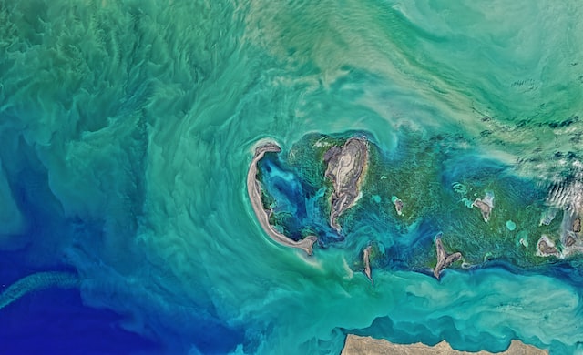
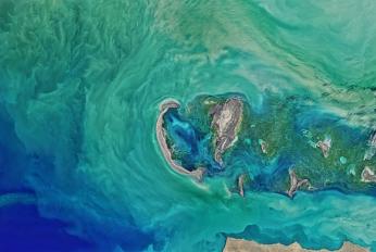
 Колебания уровня каспийского моря и диагностика современных изменений положения береговой линии по спутниковым данным Landsat периода 2005…2015 годовчт, 08/09/2018 - 13:45Рассмотрены вопросы, связанные с проблемой колебаний уровня Каспийского моря и их влияний на прибрежную зону казах-станского сектора. По данным картирования спутниковых снимков площадь осушения в северо-восточной части Каспийского моря в период между 2005 и 2015 гг. составила 5055 км2. В некоторых районах море отступило на 2
- Описание
Рассмотрены вопросы, связанные с проблемой колебаний уровня Каспийского моря и их влияний на прибрежную зону казах-станского сектора. По данным картирования спутниковых снимков площадь осушения в северо-восточной части Каспийского моря в период между 2005 и 2015 гг. составила 5055 км2. В некоторых районах море отступило на 25 км
- Attached documents
- Metadata
- Год
- 2015
 Caspian Environment Programme - Contaminants from Terek River into Caspian Sea (2007)вт, 06/12/2018 - 11:43In the frame of the current Project the estimation on contents of nutrients, petroleum hydrocarbons, phenols and heavy metals in water and bottom sediments in the basins of rivers Terek, Sulak and Samur over the last years was carried out. Research was conducted within a framework of the State Monitoring Programme on Roshydr
- Описание
In the frame of the current Project the estimation on contents of nutrients, petroleum hydrocarbons, phenols and heavy metals in water and bottom sediments in the basins of rivers Terek, Sulak and Samur over the last years was carried out. Research was conducted within a framework of the State Monitoring Programme on Roshydromet in the central and lower parts of the Terek delta. The data of Roshydromet standard investigations was used to assess the concentration of pollutants, namely petroleum hydrocarbons, heavy metals, phenols, detergents, nutrients (nitrites, nitrates, ammonium and total nitrogen) and silicates, and also expenditure of river water during the estimation of their flows at hydrological Karagalinsky hydro system and
Alikazgan stations in the Terek delta. The Roshydromet data cover the period 2002-2005.- Attached documents
- Metadata
- Год
- 2007
Документ
Колебания уровня каспийского моря и диагностика современных изменений положения береговой линии по спутниковым данным Landsat периода 2005…2015 годов
Документ