Документы
В этом разделе представлены общедоступные документы и файлы, загруженные заинтересованными сторонами и хранителями окружающей среды Каспийского моря.
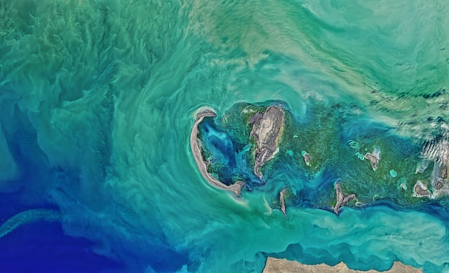
 Колебания уровня каспийского моря и диагностика современных изменений положения береговой линии по спутниковым данным Landsat периода 2005…2015 годовчт, 08/09/2018 - 13:45Рассмотрены вопросы, связанные с проблемой колебаний уровня Каспийского моря и их влияний на прибрежную зону казах-станского сектора. По данным картирования спутниковых снимков площадь осушения в северо-восточной части Каспийского моря в период между 2005 и 2015 гг. составила 5055 км2. В некоторых районах море отступило на 2
- Описание
Рассмотрены вопросы, связанные с проблемой колебаний уровня Каспийского моря и их влияний на прибрежную зону казах-станского сектора. По данным картирования спутниковых снимков площадь осушения в северо-восточной части Каспийского моря в период между 2005 и 2015 гг. составила 5055 км2. В некоторых районах море отступило на 25 км
- Attached documents
- Metadata
- Год
- 2015
 Caspian Environment Programme - Regional Water Quality Monitoring (2009)вт, 06/12/2018 - 11:51This Regional Water Quality Monitoring Programme has been developed as part of the project “Caspian Water Quality Monitoring and Action Plan for Areas of Pollution Concern’s (Caspian MAP)”. This project has been financed by the Tacis Programme of the European Union (EU) which amongst others promotes regional co-operation on
- Описание
This Regional Water Quality Monitoring Programme has been developed as part of the project “Caspian Water Quality Monitoring and Action Plan for Areas of Pollution Concern’s (Caspian MAP)”. This project has been financed by the Tacis Programme of the European Union (EU) which amongst others promotes regional co-operation on environmental protection. On of the main objectives of the Caspian MAP is to support the Caspian Environment Programme (CEP), which is a partnership between the five littoral states - Azerbaijan, Islamic Republic of Iran, Kazakhstan, Russian Federation and Turkmenistan, and International Partners like EU, UNDP, UNEP, and the World Bank. The CEP's mission is to assist the Caspian littoral states to achieve the goal of environmentally sustainable development and management of the Caspian environment for the sake of long-term benefit for the Caspian inhabitants.
- Attached documents
- Metadata
- Год
- 2009
 Caspian Environment Programme - Regional Pollution Action Plan (2009)вт, 06/12/2018 - 11:48The Regional Pollution Action Plan for the Caspian Sea (RPAP), has been prepared as part of the project “Caspian Water Quality Monitoring and Action Plan for Areas of Pollution Concern’s (hereafter: Caspian MAP)”. The project is financed by the Tacis Programme of the European Union (EU), which has as one of its objectives th
- Описание
The Regional Pollution Action Plan for the Caspian Sea (RPAP), has been prepared as part of the project “Caspian Water Quality Monitoring and Action Plan for Areas of Pollution Concern’s (hereafter: Caspian MAP)”. The project is financed by the Tacis Programme of the European Union (EU), which has as one of its objectives the promotion of regional co-operation on environmental protection. The overall objective of the Caspian MAP is to achieve improved quality of the marine and coastal environment of the Caspian Sea. In particular, the RPAP (current Report) provides recommendations to regional strategies for pollution reduction, with a focus on the identified Areas of Pollution Concern. The Caspian MAP also developed a proposal for a Regional Water Quality Monitoring Program.
- Attached documents
- Metadata
- Год
- 2009
Документ
Колебания уровня каспийского моря и диагностика современных изменений положения береговой линии по спутниковым данным Landsat периода 2005…2015 годов
Документ

Caspian Environment Programme - Regional Water Quality Monitoring (2009)
Документ