Документы
В этом разделе представлены общедоступные документы и файлы, загруженные заинтересованными сторонами и хранителями окружающей среды Каспийского моря.
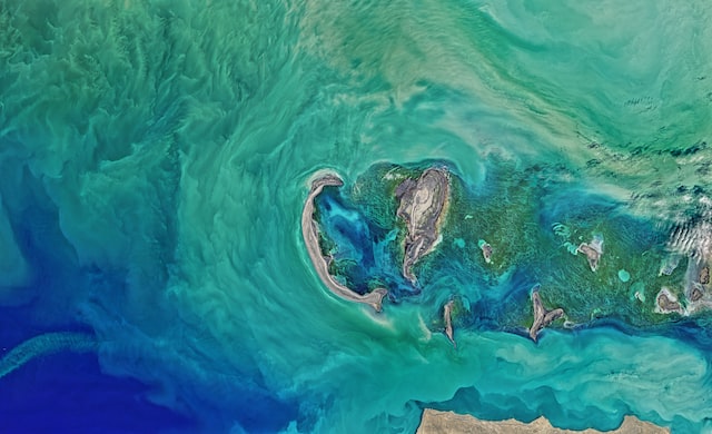
 Caspian Sea State of Environment Report - SoE 1 (2011)пт, 02/17/2023 - 08:53The Caspian Sea, abundant with natural living and fossil resources, its coastal areas home to more than 15 million people, faces a series of environmental challenges. This State of the Caspian Sea Environment Report should be seen and considered as a first try out and starting point towards the creation of a shared environm
- Описание
The Caspian Sea, abundant with natural living and fossil resources, its coastal areas home to more than 15 million people, faces a series of environmental challenges.
This State of the Caspian Sea Environment Report should be seen and considered as a first try out and starting point towards the creation of a shared environmental information system promoting and securing data collection, monitoring, analysis, harmonization and public communication in support of full implementation of the Tehran Convention and its protocols. We hope that it will improve the Caspian information base, enhance the quality, accessibility and relevance of data and ultimately, contribute to strengthening the regional environmental governance framework.
The Caspian Sea SoE 1 Report in higher resolution can be dowloaded here.
- Attached documents
- Metadata
- Год
- 2011
 Article - Effects of Caspian Sea water level fluctuations on existing drainsпн, 04/23/2018 - 19:18This study is an attempt to develop an integrated methodology to predict the impact of the Caspian Sea on flooding using Geographic Information Systems (GIS) and hydrodynamic modeling. A rise in the sea level might lead to major flooding events, and have a severe impact on the spatial development of cities and regions. The f
- Описание
This study is an attempt to develop an integrated methodology to predict the impact of the Caspian Sea on flooding using Geographic Information Systems (GIS) and hydrodynamic modeling. A rise in the sea level might lead to major flooding events, and have a severe impact on the spatial development of cities and regions. The feasibility of simulating a flood event along a drain channel is evaluated near residential development areas along the Chapakroud drain.
The study shows that at these elevations environmental and social problems arise with regards to the drain. The results also indicate that GIS is an effective tool for floodplain visualization and analysis. It should be noted that the mixture of salt and soft water, as a result of rising sea water level, is a problem that was not investigated in this study and should be examined in the future.
- Attached documents
- Metadata
- Год
- 2011
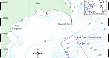
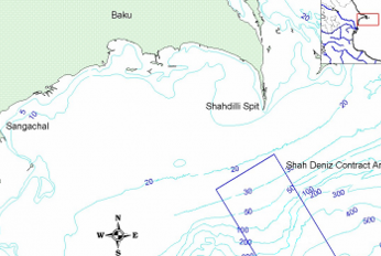 Post Drill Environmental Survey August 2010 AmC Project 10804вт, 04/17/2018 - 13:32Technical Summary Sampling was conducted from the vessel Svetlomor 2 by personnel from AmC, the Ministry of Ecology and Natural Resources (MENR) and SOCAR. Sediment samples for physical and chemical analysis consisted of 2 replicates, while 3 replicates were taken for biological analyses. Analyses were carried out at AmC Ca+5
- Описание
Technical Summary
Sampling was conducted from the vessel Svetlomor 2 by personnel from AmC, the Ministry of Ecology and Natural Resources (MENR) and SOCAR. Sediment samples for physical and chemical analysis consisted of 2 replicates, while 3 replicates were taken for biological analyses. Analyses were carried out at AmC Caspian Environmental Laboratory.
In general the survey stations around the SDX-5 well site were found to have well sorted very fine silt sediments with low variation in metal and hydrocarbon concentrations.
Relationships were found to be present between metals Cr, Cu, Fe, Mn, Pb and Zn. With the exception of phenols all hydrocarbon parameters were interrelated, with the proportions of UCM and NPD indicating that all hydrocarbons present were weathered.
The macrobenthic community had a low abundance and species richness and was characteristic of the area and depth. Overall no relationship was found to exist between any of the measured variables and the community structure, with the low species richness and abundance likely being due to the depth of the survey area exceeding 500m.
Comparison to previous baseline data indicated change at one station adjacent to the well location. Samples from this station indicated the presence of WBM contaminated drill cuttings, with coarser grained sediments, very high concentrations of Ba and the absence of the metal relationships evident at all other stations.
Hydrocarbon analysis of samples from this position revealed an LAO signature indicating the presence of SBM in addition to the WBM. These samples also had a high proportion of NPD which suggests the likely presence of cuttings contaminated with LAO and also reservoir fluids.
LAO was detected in one other sample and two stations had slightly elevated concentrations of Ba.
- Attached documents
- Metadata
- Год
- 2011
Документ
Caspian Sea State of Environment Report - SoE 1 (2011)
Документ
Article - Effects of Caspian Sea water level fluctuations on existing drains
Документ