Документы
В этом разделе представлены общедоступные документы и файлы, загруженные заинтересованными сторонами и хранителями окружающей среды Каспийского моря.
 Report on the Caspian Sea Day in Russia in 2012ср, 03/26/2025 - 11:11In 2012 all events related to the Caspian Day that took place in the Caspian littoral subjects of the Russian Federation were held via the organization of various conferences, seminars for scholars, Olympiads, actions, and campaigns to clean-up the shores of the rivers and the Caspian Sea.
- Описание
In 2012 all events related to the Caspian Day that took place in the Caspian littoral subjects of the Russian Federation were held via the organization of various conferences, seminars for scholars, Olympiads, actions, and campaigns to clean-up the shores of the rivers and the Caspian Sea.
- Attached documents
- Metadata
- Год
- 2012
 KZ Report: Legislative and institutional frameworks for the protection and sustainable management of the Caspian Sea environmentсб, 12/21/2024 - 15:40In the Caspian Sea basin Mangistauskaya and Atyrauskaya oblast of Kazakhstan are located. The Ecological program of Mangistuskaya oblast for 2005-2007 directed to solve such problems as liquidation of historical pollution, biodiversity conservation and prevention of desertification and soil degradation, reduction of the volu
- Описание
In the Caspian Sea basin Mangistauskaya and Atyrauskaya oblast of Kazakhstan are located. The Ecological program of Mangistuskaya oblast for 2005-2007 directed to solve such problems as liquidation of historical pollution, biodiversity conservation and prevention of desertification and soil degradation, reduction of the volumes of industrial and household waste, etc. All regional programs are obligatory submitted to the approval of Ministry of Environment Protection of Republic of Kazakhstan (MoEP RK), and then it can be approved in regional Maslikhats. The Ecological program of Atyrauskaya oblast for 2006 - 2008 is approved in the MoEP and now is on the confirmation in the regional Maslikhat.
- Attached documents
- Metadata
- Год
- 2006
- Report: Fisheries Management in the Caspian Sea, 2006сб, 12/21/2024 - 15:00The Caspian Sea, world largest lake, is bordered by Azerbaijan Republic, Islamic Republic of Iran, Kazakhstan, Republic, Russian Federation and Turkmenistan. Its biodiversity is comprised of 1354 plant, animal and more than 122 fish species. Out of 122 fish species and subspecies living in the Caspian Sea, 40 species are com
- Описание
The Caspian Sea, world largest lake, is bordered by Azerbaijan Republic, Islamic Republic of Iran, Kazakhstan, Republic, Russian Federation and Turkmenistan. Its biodiversity is comprised of 1354 plant, animal and more than 122 fish species. Out of 122 fish species and subspecies living in the Caspian Sea, 40 species are commercial and presently 25 species are the main exploited fish. The Caspian Sea fishes are divided to four main groups, including 53 species Marine fishes (43.5%), 42 species (13.4%) of freshwater origin, 18 species (14.7%) anadromous and 9 species (7.4%) semi-anadromous. At present sturgeons, kilka and Caspian Sea seals are considered as shared stocks between Caspian Sea range states.
- Attached documents
- Metadata
- Год
- 2006
 1st_National Report_Russian Federation_in 2006-2007_for_Tehran Convention_-engвс, 03/26/2023 - 21:46The first national report of the Russian Federation on the implementation of the Tehran Convention was prepared in 2012 for 2006-2007 - from the moment of entry into force of the Convention. The National Report for 2006-2007 of the volume of 79 pages in Russian and 73 pages in English was prepared by “CIP“ (T.Butylina, A.Sav
- Описание
The first national report of the Russian Federation on the implementation of the Tehran Convention was prepared in 2012 for 2006-2007 - from the moment of entry into force of the Convention. The National Report for 2006-2007 of the volume of 79 pages in Russian and 73 pages in English was prepared by “CIP“ (T.Butylina, A.Savelyev, V.Markov, Zh.Novoselova) with financial support of the Ministry of Natural Resources of Russia.
The first national report of the Russian Federation based on a unified reporting format adopted in 2011 on KS-3 as a recommended scheme for the presentation of information by the Caspian countries. The National Report for 2006-2007 characterizes the organizational and administrative structure of the performance of obligations under the Convention, including the data of the relevant federal and regional integrated and thematic plans and development programs, as well as information on parameters, evaluations and trends and changes in the state of marine and coastal environment of the region.Первый национальный доклад Российской Федерации по реализации Тегеранской конвенции подготовлен в 2012 году за 2006-2007гг. – с момента вступления в силу Конвенции. Отчет был разработан в соответствии с решениями третьей сессии Конференции Сторон (КС-3, 2011г, Актау) на основе Унифицированного формата отчетности, принятого в 2011г на КС-3 в качестве рекомендуемой схемы представления информации прикаспийскими странами.
Национальный доклад за 2006-2007гг (объемом 79 стр. на русском и 73 стр. на английском языках) основан на анализе открытой различной тематической информации о состоянии окружающей среды и природоохранной деятельности в прикаспийских регионах России.
Специфика первых национальных докладов состоит в том, что они разрабатывались в отсутствие конвенции о правовом статусе Каспия.
Информация и данные,представленные в первом национальном докладе за 2006-2007гг. в рамках Тегеранской конвенции обозначили подходы российской национальной природоохранной политики на Каспии, которая рассматривает Каспий как единый географически и экологически системно-целостный объект. Любое воздействие на морскую среду Каспийского моря, где бы оно ни произошло, становится, в принципе, - трансграничным. Все проблемы, связанные с хозяйственной и иной деятельностью на акватории Каспия, решаются исключительно по соглашению прикаспийских государств.
Национальный доклад за 2006-2007гг характеризует организационно-административную структуру деятельности и информационного обеспечения выполнения обязательств по Конвенции, включая данные соответствующих федеральных и региональных комплексных и тематических планов и программ развития, а также информацию о параметрах, оценках и тенденциях и изменения состояния морской и прибрежной окружающей среды региона.
Доклад подготовлен «ЦМП» (Т.П.Бутылина, А.В. Савельев, В.А. Марков, Ж.Г. Новоселова) при финансовой поддержке Минприроды России.- Attached documents
- Metadata
- Год
- 2012
 Caspian Environment Monitoring Programme - 2012пн, 02/20/2023 - 14:41Unified, Integrated and Affordable Caspian Environment Monitoring Programme Among the Contracting Parties to the Framework Convention for the Protection of the Marine Environment of the Caspian Sea was welcomed at COP4, Moscow, Russian Federation, 10-12 December 2012. The objectives of the EMP to develop a framework providi
- Описание
Unified, Integrated and Affordable Caspian Environment Monitoring Programme Among the Contracting Parties to the Framework Convention for the Protection of the Marine Environment of the Caspian Sea was welcomed at COP4, Moscow, Russian Federation, 10-12 December 2012.
The objectives of the EMP to develop a framework providing the necessary data and information on the Caspian environment in order to; initially provide data on the state of the Caspian environment, highlight pollution problems, provide biological related data which will support the broad objective of tracking changes of the health and diversity of ecosystems in, and adjacent to, the Caspian Sea.
- Attached documents
- Metadata
- Год
- 2012
 National Convention Action Plan NCAP 2012вс, 04/22/2018 - 20:06National Convention Action Plan NCAP of the five Parties - Year 2012+9
- Описание
National Convention Action Plan NCAP of the five Parties - Year 2012
- Attached documents
- Metadata
- Год
- 2012
 Celebration of Caspian Day in Turkmenistan: Final Reportвс, 04/22/2018 - 07:45Objectives of the project included the organization and performance of the coast-wide awareness campaign in Turkmenbashi and Awaza area devoted to the Caspian Sea Day celebration. The project was prepared and agreed with the program of Celebration with the Ministry of Nature Protection of Turkmenistan, which supposed to be h
- Описание
Objectives of the project included the organization and performance of the coast-wide awareness campaign in Turkmenbashi and Awaza area devoted to the Caspian Sea Day celebration. The project was prepared and agreed with the program of Celebration with the Ministry of Nature Protection of Turkmenistan, which supposed to be held in hotel “Dayanch” on the Caspian coast. The events were planned for August 10-11, 2012. However due to force-major reasons, upon arrival of participants of the event to Turkmenbashy city, the organizers were asked to postpone the event. It was decided to perform it in Ashgabat at the premises of the Institute of Deserts. Due to the summer beach time, it was impossible to change tickets and go back to Ashgabat earlier. Thus the Caspian Day event was then again prepared and performed in Ashgabat.
- Attached documents
- Metadata
- Год
- 2012
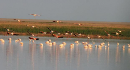
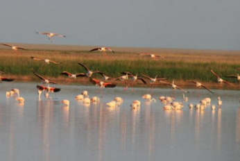 Akzhaiyk Reserve General Informationсб, 04/21/2018 - 11:16State Nature Reserve "Akzhaiyk" (Kazakh "Aқzhayyқ" memlekettіk tabiғi reserves) is located in the Makhambet Atyrau region, in the surrounding lands outside the city of Atyrau. It was created by the Government of the Republic of Kazakhstan on February 6, 2009 in the delta of the Ural River and the adjacent coast of the Caspia
- Описание
State Nature Reserve "Akzhaiyk" (Kazakh "Aқzhayyқ" memlekettіk tabiғi reserves) is located in the Makhambet Atyrau region, in the surrounding lands outside the city of Atyrau. It was created by the Government of the Republic of Kazakhstan on February 6, 2009 in the delta of the Ural River and the adjacent coast of the Caspian Sea. [1] The Ural River Delta and the adjacent coast of the Caspian Sea is included in the list of wetlands of international importance. The reserve was the second Kazakh territory after the Tengiz-Korgalzhyn lake system, which went down in the list. The hydrological regime is characterized by a gradual rise the water level in the Ural River in the second half of April, with the transition in May-June in spring and summer, with a peak at the end of May or the first half of of June. After the first flood peak starts fast and then gradual decline, passing in August and September in the autumn low water.
- Attached documents
- Metadata
- Год
- 2012
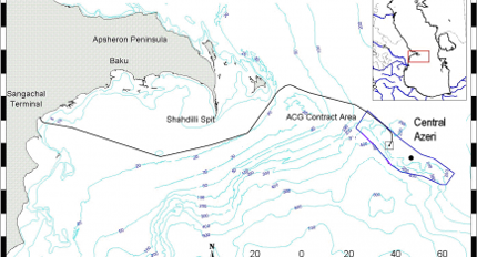
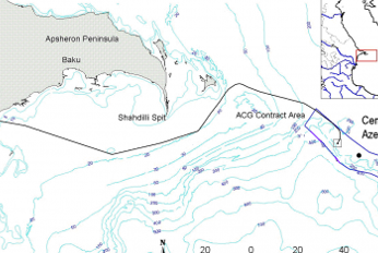 Central Azeri Environmental Survey July 2010 AmC Project 10502вт, 04/17/2018 - 15:02Sampling was conducted from the vessel Svetlomor 2 by personnel from AmC, the Ministry of Ecology and Natural Resources (MENR) and SOCAR. Sediment samples for physical and chemical analysis consisted of 2 replicates, while 3 replicates were taken for biological analyses. Analyses were carried out at AmC Caspian Environmental+5
- Описание
Sampling was conducted from the vessel Svetlomor 2 by personnel from AmC, the Ministry of Ecology and Natural Resources (MENR) and SOCAR. Sediment samples for physical and chemical analysis consisted of 2 replicates, while 3 replicates were taken for biological analyses. Analyses were carried out at AmC Caspian Environmental Laboratory.
Sediments around Central Azeri were very poorly sorted, the majority being a mixture of sand and gravel. At many stations, the two replicates were substantially different, indicating patchiness of physical characteristics on a small spatial scale (metres).
LAO was detected at 7 stations in 2010. There was little evidence of change at the majority of stations, and the overall area within which LAO was observed remains very similar to that observed in previous surveys. In general the hydrocarbon concentrations were low or very low and UCM and NPD content were indicative of weathered material being present throughout the survey area.
For the majority of trace metals the data show no clear trends or gradients which could be associated with platform activities. Three elements – barium, cadmium, and lead – exhibited very similar concentration patterns. These were the only elements which indicated a ‘footprint’ which was spatially related to the platform location. A similar association was evident in the 2008 data.
The macrobenthic community was numerically dominated by amphipods which were also the most taxonomically rich group. There was a general tendency towards lower species richness and abundance at stations to the north of, and immediately to the south of, the platform, as was also noted in 2008.
The 2010 data for sediment composition, chemistry and macrobenthic biology suggest that there is an area immediately around the platform in which some degree of sediment alteration is present, and where there is a slightly lower macrobenthic community biomass and diversity relative to more distant stations. However, there are no stations which could be considered biologically impoverished compared to previous surveys.
- Attached documents
- Metadata
- Год
- 2012
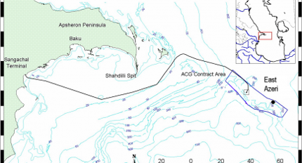
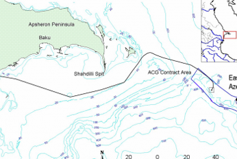 East Azeri Environmental Survey July/August 2010 AmC Project 10503пн, 04/16/2018 - 16:17Technical Summary Sampling was conducted from the vessel Svetlomor 2 by personnel from AmC, the Ministry of Ecology and Natural Resources (MENR) and SOCAR. Sediment samples for physical and chemical analysis consisted of 2 replicates, while 3 replicates were taken for biological analyses. Analyses were carried out at AmC Ca+5
- Описание
Technical Summary
Sampling was conducted from the vessel Svetlomor 2 by personnel from AmC, the Ministry of Ecology and Natural Resources (MENR) and SOCAR. Sediment samples for physical and chemical analysis consisted of 2 replicates, while 3 replicates were taken for biological analyses. Analyses were carried out at AmC Caspian Environmental Laboratory.
The sediments around East Azeri were very poorly sorted with generally good agreement between replicate samples.Variation between metal concentrations was low.
Metal and hydrocarbon concentrations were, with the exception of Ba and Cd, within the range of baseline conditions for the ACG contract area, and in many instances were lower in 2010 than in 2008.
The condition of the macrobenthic community throughout the survey area was, in 2010, better than in 2008, and was closer to the original baseline conditions. There was no evidence that any physical or chemical parameter was associated with impaired community structure or function, although it was clear that the dominant taxonomic groups were more diverse and abundant in coarser sediments.
Specifically, the results of the 2010 survey show no evidence of sustained impact as a result of continuing platform drilling and production operations; there has (with the possible exception of Cd) been no evidence of direct contamination, and the diversity, abundance and biomass of the macrobenthic community has improved since 2008.
- Attached documents
- Metadata
- Год
- 2012
Документ

Report on the Caspian Sea Day in Russia in 2012
Документ

KZ Report: Legislative and institutional frameworks for the protection and sustainable management of the Caspian Sea environment
Документ
Report: Fisheries Management in the Caspian Sea, 2006
Документ
1st_National Report_Russian Federation_in 2006-2007_for_Tehran Convention_-eng
Документ
Caspian Environment Monitoring Programme - 2012
Документ
National Convention Action Plan NCAP 2012
Документ

Celebration of Caspian Day in Turkmenistan: Final Report
Документ
Akzhaiyk Reserve General Information
Документ
Central Azeri Environmental Survey July 2010 AmC Project 10502
Документ